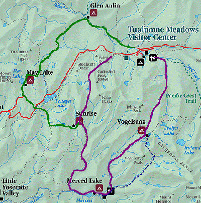
This is a map of the region of the High Sierra Camps, in the heart of the Yosemite back country. Click on the map near a camp name to view a page about that camp, or click on the links at the left for other pages.

There are six High Sierra camps (HSC); nominally a day's hike from one to another. The elevation ranges from 7100' (Merced Lake) to 10,300' (Vogelsang), making for breathtaking hiking. The camps provide lodging and meals for those fortunate to get reservations. Generally they are open from mid July to a week after Labor Day. There is a backpacking camp adjacent to each HSC.
A popular trip is to make a loop of all the camps: see the brief description on the Tuolumne page.
Although Tuolumne Meadows Lodge is on the Tioga Pass Road, about an hour's drive from Yosemite Valley, it is considered a High Sierra Camp, as is the smaller White Wolf Lodge, about 15 miles to the west. It thus serves as a good roadhead for hikes to the other camps. You can also start at Tenaya Lake or the Budd Creek trailheads. Trails to the north go into the Tuolumne River canyon. Those to the south into the Merced River watershed.
Summer weather is generally pleasantly warm during the day (70's). Nighttime temps can get down to freezing. Brief afternoon showers, sometimes with lightning and thunder, are common but do not last. Mosquitos cam be a problem in June but usually have diminished considerably by mid-July.
question: How can they have permanent structures, with all the amenities, located in an officially designated wilderness? - Each of the HSC areas has been designated an "enclave" in the wilderness. This enabled the Park Service to legally accomodate facilities that were constructed long before the wilderness designation was legislated.